Average Ratings 0 Ratings
Average Ratings 0 Ratings
Similar Products
-
TinyPNGTinyPNG (by Tinify) is a free image optimization service built for developers and designers. It utilizes smart lossy compression to reduce the file sizes of JPEG, PNG, WebP, and AVIF files by up to 80% with no visible quality loss. That means faster load times, better SEO, and lower bandwidth. You can compress, convert, and resize images via a clean web interface or integrate it into your workflow with the API. The platform also provides an image CDN for fast global delivery of optimized assets. SDKs are available for Python, Node.js, PHP, Java, Ruby, and .NET. WordPress plugin included, plus plenty of community-driven integrations. No tuning, no noise, Tinify just works. Whether you're optimizing a handful of images or processing millions, it scales effortlessly. All plans include a generous free tier, and support is quick when you need it. George the panda 🐼 approves.
-
Teradata VantageCloudTeradata VantageCloud: Open, Scalable Cloud Analytics for AI VantageCloud is Teradata’s cloud-native analytics and data platform designed for performance and flexibility. It unifies data from multiple sources, supports complex analytics at scale, and makes it easier to deploy AI and machine learning models in production. With built-in support for multi-cloud and hybrid deployments, VantageCloud lets organizations manage data across AWS, Azure, Google Cloud, and on-prem environments without vendor lock-in. Its open architecture integrates with modern data tools and standard formats, giving developers and data teams freedom to innovate while keeping costs predictable.
-
Shape SoftwareShape Software's purpose-built sales and marketing automation software empowers you to manage all aspects of your business from one platform. The cloud-based software from Shape offers many tools to help you manage and automate your online marketing, promotions via text, email and digital marketing ads, capture leads from online sources, nurture prospects and customers and project manage your day. You can also offer customers a secure portal to streamline your intake processes, systematically score leads with ShapeIQ, and run detailed custom reporting. Start growing your revenue with Shape's flexible suite of services today.
-
OdooOdoo is an open-source, fully customizable and extensible software that includes hundreds of professionally designed business applications. Odoo's intuitive database can meet most business needs including CRM, Sales, Projects, Manufacturing, Inventory, Accounting, and Accounting. Odoo is a software solution that can be used to meet all company needs, regardless of size or budget. Odoo's seamless design makes it easy for businesses to become more efficient and save time. Each module is interconnected to offer a seamless experience from one app to the next. Users can automate many tasks that would otherwise require manual inputs to multiple applications. Odoo enables teams to collaborate with each other from one platform, allowing them to keep all business functions in one place.
-
ApifyApify provides the infrastructure developers need to build, deploy, and monetize web automation tools. The platform centers on Apify Store, a marketplace featuring 10,000+ community-built Actors. These are serverless programs that scrape websites, automate browser tasks, and power AI agents. Developers create Actors using JavaScript, Python, or Crawlee (Apify's open-source crawling library), then publish them to the Store. When other users run your Actor, you earn money. Apify manages the infrastructure, handles payments, and processes monthly payouts to thousands of active developers. Apify Store offers ready-to-use solutions for common use cases: extracting data from Amazon, Google Maps, and social platforms; monitoring prices; generating leads; and much more. Under the hood, Actors automatically manage proxy rotation, CAPTCHA solving, JavaScript-heavy pages, and headless browser orchestration. The platform scales on demand with 99.95% uptime and maintains SOC2, GDPR, and CCPA compliance. For workflow automation, Apify connects to Zapier, Make, n8n, and LangChain. The platform also offers an MCP server, enabling AI assistants like Claude to discover and invoke Actors programmatically.
-
QlooQloo, the "Cultural AI", is capable of decoding and forecasting consumer tastes around the world. Privacy-first API that predicts global consumer preferences, catalogs hundreds of million of cultural entities, and is privacy-first. Our API provides contextualized personalization and insight based on deep understanding of consumer behavior. We have access to more than 575,000,000 people, places, and things. Our technology allows you to see beyond trends and discover the connections that underlie people's tastes in their world. Our vast library includes entities such as brands, music, film and fashion. We also have information about notable people. Results are delivered in milliseconds. They can be weighted with factors like regionalization and real time popularity. Companies who want to use best-in-class data to enhance their customer experiences. Our flagship recommendation API provides results based on demographics and preferences, cultural entities, metadata, geolocational factors, and metadata.
-
ShapeNetSince 2022, ShapeNet management software has been implemented in hundreds of health clubs, country clubs and wellness centers. Services include Texting, Mobile Apps, Scheduling, POS, Door Access, Loyalty Points, Sales CRM, Billing, Fitness Videos, and the ability to pass CC fees to your members. Our software will increase Employee Productivity and Improve your Member retention.
-
Google Cloud RunFully managed compute platform to deploy and scale containerized applications securely and quickly. You can write code in your favorite languages, including Go, Python, Java Ruby, Node.js and other languages. For a simple developer experience, we abstract away all infrastructure management. It is built upon the open standard Knative which allows for portability of your applications. You can write code the way you want by deploying any container that listens to events or requests. You can create applications in your preferred language with your favorite dependencies, tools, and deploy them within seconds. Cloud Run abstracts away all infrastructure management by automatically scaling up and down from zero almost instantaneously--depending on traffic. Cloud Run only charges for the resources you use. Cloud Run makes app development and deployment easier and more efficient. Cloud Run is fully integrated with Cloud Code and Cloud Build, Cloud Monitoring and Cloud Logging to provide a better developer experience.
-
BoosteroBoostero is a social media marketing (SMM) panel, a single dashboard where creators, brands, and agencies grow across 23+ platforms including Instagram, TikTok, YouTube, Facebook, X, Spotify, Telegram and LinkedIn. Followers, likes, views and engagement are ordered from one place instead of one network at a time. Operating since 2020 from Delaware, Boostero has delivered over 12 million orders for 211,000 registered users in 125+ countries, across 1,600 services, with localized pages for 19 markets and 16 languages plus English. What separates it is what is visible before you pay: the price per 1,000, the minimum and maximum order, the refill terms and an average delivery time computed from completed orders are all shown on the service itself, not promised site-wide. Ordering needs a public link or username, never a password. Key features: 23+ platforms and 1,600 services in one dashboard Service quality tiers and refill terms stated on each service before checkout Average delivery time shown per service, computed from completed orders REST API with ten documented calls and examples in PHP, Python, Node and curl White-label child panels for agencies and resellers Payments: cards, PayPal, cryptocurrency, Payoneer 24/7 support via Telegram, email and the ticket system Encrypted checkout, no password required
-
SuttonSutton is a manufacturing and distribution ERP platform that combines core operations management with AI-driven automation and customizable applications. The software centralizes inventory, warehousing, sales, purchasing, production, fulfillment, traceability, and compliance in one system. Inventory capabilities include real-time stock visibility, multi-location management, demand forecasting, shipping workflows, and monitoring of materials that may run out. Production features support shop-floor control, production scheduling, work centers, materials, jobs, and operational tracking. Sutton’s intelligence layer analyzes operational data to surface business health, identify exceptions, recommend next steps, and help users act on those recommendations. AI agents can prepare purchase orders, respond to changing production requirements, generate shipping documents, and handle other repetitive operational tasks across modules. Sutton Studio allows users to create custom apps, reports, forms, and workflows by describing what they need in plain English, with the resulting tools operating directly on existing Sutton data and permissions. The platform also includes an AI-assisted onboarding process that can reformat data, map fields, make bulk edits, and configure the system for migration. Sutton integrates with ecommerce, accounting, and sales channels such as QuickBooks, Shopify, WooCommerce, Amazon, and eBay and provides flexible API access for connecting additional systems.
Description
GeoPandas is a community-driven open-source initiative designed to simplify the handling of geospatial data within Python. By expanding upon the data types available in pandas, GeoPandas facilitates spatial operations on geometric data types. The library utilizes shapely for executing geometric functions, while it relies on fiona for file management and matplotlib for visualization purposes. The primary aim of GeoPandas is to streamline the process of working with geospatial data in Python. This tool integrates the functionalities of both pandas and shapely, allowing users to perform geospatial tasks seamlessly within the pandas framework and providing an accessible interface for various geometric operations through shapely. With GeoPandas, users can conduct operations in Python that typically would necessitate a spatial database like PostGIS. The project is supported, developed, and utilized by a diverse global community of individuals with varying expertise. It remains committed to being fully open-source, available for everyone to utilize, and is released under the permissive BSD-3-Clause license, ensuring its continued accessibility and growth. As such, GeoPandas serves as a powerful resource for anyone looking to work with geospatial data in a user-friendly manner.
Description
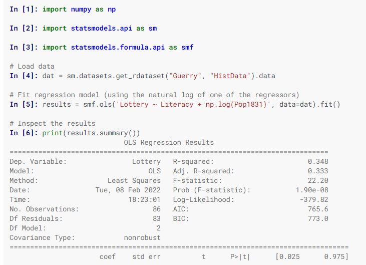
Statsmodels is a Python library designed for the estimation of various statistical models, enabling users to perform statistical tests and explore data effectively. Each estimator comes with a comprehensive array of result statistics, which are validated against established statistical software to ensure accuracy. This package is distributed under the open-source Modified BSD (3-clause) license, promoting free use and modification. Users can specify models using R-style formulas or utilize pandas DataFrames for convenience. To discover available results, you can check dir(results), and you will find that attributes are detailed in results.__doc__, while methods include their own docstrings for further guidance. Additionally, numpy arrays can be employed as an alternative to formulas. For most users, the simplest way to install statsmodels is through the Anaconda distribution, which caters to data analysis and scientific computing across various platforms. Overall, statsmodels serves as a powerful tool for statisticians and data analysts alike.
API Access
Has API
No
API Access
Has API
Yes



Integrations
Anaconda
No
Google Earth Engine
Yes
Python
No
Union Pandera
Yes
Integrations
Anaconda
Yes
Google Earth Engine
No
Python
Yes
Union Pandera
No
Pricing Details
No price information available.
Free Trial
No
Free Version
Yes
Pricing Details
Free
Free Trial
No
Free Version
Yes
Deployment
Web-Based
Yes
On-Premises
No
iPhone App
No
iPad App
No
Android App
No
Windows
No
Mac
No
Linux
No
Chromebook
No
Deployment
Web-Based
No
On-Premises
No
iPhone App
No
iPad App
No
Android App
No
Windows
Yes
Mac
Yes
Linux
Yes
Chromebook
No
Customer Support
Business Hours
No
Live Rep (24/7)
No
Online Support
Yes
Customer Support
Business Hours
No
Live Rep (24/7)
No
Online Support
Yes
Types of Training
Training Docs
Yes
Webinars
No
Live Training (Online)
No
In Person
No
Types of Training
Training Docs
Yes
Webinars
No
Live Training (Online)
No
In Person
No
Vendor Details
Company Name
GeoPandas
Founded
2013
Website
geopandas.org/en/stable/
Vendor Details
Company Name
statsmodels
Website
www.statsmodels.org/stable/index.html
Product Features
GIS
3D Imagery
No
Census Data Integration
No
Color Coding
No
Geocoding
No
Image Exporting
No
Image Management
No
Internet Mapping
No
Interoperability
No
Labeling
No
Map Creation
No
Map Sharing
No
Near-Matching
No
Reverse Geocoding
No
Spatial Analysis
No
